 Fort Roberdeau was a stockaded structure, apparently the only one in the present-day Blair County region to have been authorized by the Pennsylvania Assembly, built expressly for the security and protection of the men engaged in mining the lead that was abundant in the Sinking Spring Valley.
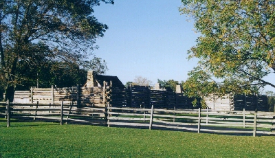
![]() Fort Roberdeau is the only one of the six fortified structures known to have been constructed within the limits of present-day Blair County during the American Revolutionary War to be reconstructed.
Fort Roberdeau is the only one of the six fortified structures known to have been constructed within the limits of present-day Blair County during the American Revolutionary War to be reconstructed.
The numerous veins of lead that were believed to exist in the soil of the valley lying between the twin ridges of Brush Mountain drew the attention of the Patriots during the Revolutionary War. It has been claimed that the French were the first to attempt to extract the valuable mineral from the Sinking Spring Valley. Although not proven by any surviving documentation, the French who claimed trading rights throughout the region west of the Susquehanna River may have learned of the lead deposits as early as 1750 from the Indians who inhabited this region. Apparently, these early lead miners had opened a number of pits and dug a trench nearly six miles in length to connect various mines.
On 23 February 1778 Major General John Armstrong wrote to Thomas Wharton, Jr, the President of the Supreme Executive Council of the State of Pennsylvania to acquaint him with the fact that the veins of lead that lay near Frankstown would be advantageous to the Patriot cause. He noted that the mine on the Proprietaries' Sinking Valley tract of 9,056 acres, which occupied roughly the entire valley formed by the V-shaped Brush Mountain, should be seized by the newly declared state of Pennsylvania for its use.
Sir, As at present there appears to be a Scarcity of the important article of Lead, and it's certain a Mr. Harmon Husbands, now a member of Assembly for our State, has some knowledge of a Lead Mine, situate in a certain Tract of Land not far from Franks Town, formerly surveyed for the use of the Proprietary Family.
General Gates, President of the Board of War, having signified his earnest desire to see & converse with Mr. Husbands on the subject of the Mine, and being greatly hurried with business, I have at his instance undertaken the present line, that you wou'd please to use yr influence with the House of Assembly, and with Mr. Husbands, that he, as soon as possible, may be spared to consult with the Board of War, on the best measures for making a tryal of & deriving an early supply from that source.
The General is of Opinion with me, that the Mine ought or may at least for the present be seized by, and belong to the State, and that private persons who without right may have sat down on that reserved Tract, shou'd neither prevent the present use of the Lead, nor be admitted to make a monopoly of the Mine. I'm of opinion that a few faithful Labourers may be sufficient to make the experiment, and that the Lieut. of the County, or some other good Man, may be serviceable in introduceing the business.
I cannot doubt the Compliance of the honorable Assembly & Council.
And am, Sir, with great respect, Yr Excellencys most.
In March of 1778 the General Assembly of Pennsylvania gave approval to General Daniel Roberdeau to begin mining operations at the site. Although its original source is not known, Eugene R. Craine, in his book The Story Of Fort Roberdeau 1777 To 1783 provided a transcription of a resolve of the General Assembly of Pennsylvania in response to an earlier petition of General Roberdeau 'with others':
On considering the petition of the Honorable Daniel Roberdeau and company, for vesting the lands therein mentioned, whereon there is a lead mine, in Frankstown Township in Bedford County, in the said Daniel Roberdeau and company, to which they lay claim; Resolve, that this house will not determine in whom the title of said lead is; but being of opinion that the utmost encouragement should be given to opening said mine and smelting the ore therein for public benefit, will indemify the said Daniel Roberdeau and company from any loss they have already sustained or may sustain in opening the said mine and smelting the ore, if they shall immediately proceed upon said work, and diligently and faithfully prosecute the same.
One of the greatest needs of the Patriot armies was ammunition. There were only a few lead mines in operation when the War started, and their output was not sufficient to meet the demand. There was a possibility of a good supply of lead in Bedford County in the valley where streams rose and sunk into the limestone based soil, giving it the name of Sinking Spring Valley. It was to this place that Daniel Roberdeau traveled in the spring of 1778.
On the 17th of April, General Roberdeau sent a letter to President Wharton from Carlisle, in Cumberland County. He wrote:
"The confidence the Honorable the Representatives of our State, have placed in me, by a late resolve, together with the pressing and indispensible necessity of a speedy supply of lead for the public Service, induced me to ask leave of absence of Congress to proceed with Workmen to put their business into a proper train, and have reached this place on that errand, and having collected men and materials and sent them forward this day, purpose to follow to-morrow. My views have been greatly enlarged since I left York, on the importance of the undertaking and hazard in prosecuting it, for the publick Works here are not furnished with an ounce of lead but what is in fixed ammunition, on the other hand the prevailing opinion of people as I advance into the Country, of Indian depredations shortly to commence, might not only deter the Workmen I stand in need of, but affright the back settlers from their Habitation sand leave the Country exposed and naked. To give confidence to one and the other, I have drawn out of the publick Stores here, twenty five stand of arms and a quantity of Gun powder, and intended to proceed this morning, but was applied to by John Caruthers, Esqr., Lieut. of this County, and Wm. Brown, Commissary of provisions for the Militia, who advised with me on the subject of their respective Departments, and by the account they gave of the orders from your Honble Board to them as to calling out and supplying the Militia, I find the State is guarding aganst the incursions of the Savages; this confirmed me in a preconceived intention of erecting a Stockade Fort, in the neighbourhood of the Mine I am about to work; if I could stir up the Inhabitants to give their labour in furnishing an Asylum for their Families in case of imminent danger, and prevent the evacuation of the Country. Mr. Caruthers, convinced of the necessity of the work for the above purposes, condescendingly offered one Company of the Militia, which he expected would consist of about 40 men, under my command , to co-operate in so salutary a Business; as it consisted with the orders of Council respecting the Station, being only a deviation of a very few miles; and that one other Company of about the same number should also join me for the greater Expedition, until the pleasure of Council was known, which he presumed might coincide with such dispositions, otherwise it might be deranged by an immediate Express, and that the pleasure of Council might be known without delay, I give this intelligence. If these measures are for the good of the publick wheel, I hope to be honored with a confirmation, and orders to the Militia to exert themselves in carrying the design into immediate execution; if otherwise, I rely on the well known candour of Council, that I shall not be suspected of any sinister design, in leaning to an offer freely made as above, from, I believe, the best motives; much less that I have presumed to interfere with the arrangements of Council, as this early notice is a full proof the Contrary, as the whole is in their power as much as if nothing had passed betwixt the Lieut. and myself. I have only to add on this subject that your design of patroling parties of good Riflemen shall be encouraged by me. The Commissary, Mr. Brown, being destitute of money, would have spared it out of my small stock, but that by my interferance 1200 Dollars, all he asked, was supplied by a public officer here, but further sums, will, he said, be soon necessary and he expressed much concern for the scarcity of provisions. I was advised very lately by Judge McKean, of a quantity of salted beef, in the neighbourhood of Harris's Ferry, and before I left York I applied to him by letter to advise me of the quantity and quality, with a design to purchase, as I intended to employ a much greater number of men than are already employed at the lead mine, to carry on the Business with vigour. If Council should think proper to order a quantity of said provisions up the Juniata, for the Militia, I should be glad of being favored with what I want thro' the same Channel. I intend to build such a Fort, as, with sufficient provisions, under the smile of providence, would enable me to defend it against any number of Indians that might presume to invest it. If I am not prevented by an opportunity of serving the State eminently by a longer stay in the Wilderness, I purpose to return to my duty in pugress in about three Weeks. Will Council favor me with the exemption of a number of men, not exceeding twenty, if I cannot be supplied by the Adjutant General who has orders co-extensive with my want of smelters and Miners from Deserters from the British Army, to suffer such to come to this part of the Country contrary to a preceeding order? If Council should think such a measure of exemption for the public good, I should be glad to receive their orders on that head. I would not intrude my sentiments on Council, but am of opinion, that besides the supplying of provisions to the Militia in Bedford, it is very important that the intended Stockade should be seasonably furnished with that article; therefore if it should not be thought adviseable to improve the above hint, that the provisions already mentioned in the neighbourhood of Harris's, should be left unnoticed until I shall have an oppo'y of furnishing my own supplies from that stock, if I shall be advised by Mr. McKean it is in my offer. My landing is at Water Street in Juniata, but I could on notice receive any supply from Standing Stone.
I am most respectfully, Sir, Yr most obt & very hum. Serv't DANIEL ROBERDEAU
P.S. In my hurry I have not time to copy this which I beg may be excused."
Continuing to travel westward, Roberdeau wrote to John Carothers on the 23rd from Standing Stone (i.e. the present-day Huntingdon). He noted that: "With ten men here under the command of Lieut. Cluggage, in continental service, untill the 1st Decr next, I intend to move forward, to afford an escort to Sinking Spring Valley, where I shall be glad to meet as great a number of militia as you will station there, to enable me to erect a Stockade to secure the works so necessary to the public service, & give confidence to the fronteer Inhabitants, by affording an Assylum for their women & children."
General Roberdeau wrote to President Wharton from Sinking Spring Valley on the 27th of April. He found that the earlier report of General Armstrong was correct as to the promise of a high yield of the valuable mineral, but he also found that the region was occasionally threatened by Indian incursions. In order to carry on the operation of mining the lead, some sort of protection would need to be provided for the miners. [Note: The Fort Roberdeau Association has dated the commencement of the construction of the fort to 27 April 1778, perhaps because General Roberdeau wrote his letter from the Sinking Spring Valley on that date. The available documentation, though, does not specifically mention the particular date on which the construction of the fortifications were begun. Therefore, assigning any specific date is merely speculation.] General Roberdeau wrote:
Sir, I have little more time than to refer you to the enclosed examination, taken in great haste, but correct as it respects the Testimony... I am happy to inform you that a very late discovery of a new vein, promises the ample supply; but I am very deficient in workmen. Mr Glen is with me to direct the making and burning of Bricks, and is to come up to build a Furnace, by which time I expect to be in such forwardness as to afford an ample supply to the Army. The want of Provision, I dread, notwithstanding the active endeavors of Mr Brown for it, is scarcely to be got; therefore I beg leave to refer you to hint on this subject in my Letter from Carlisle. Of 40 Militia, I have at most, seven with me, which retards building a Stockade to give confidence to the Inhabitants, who were all on the wing before I reached this...
It has been speculated that the construction of Fort Roberdeau took place in two stages. It is possible, though not established with certainty, that a fortified structure would have been erected immediately for the miners to live in. A blockhouse for a lookout to keep watch for anyone attempting to invade the vicinity might have been constructed close to the living quarters.
The second stage of the construction of the actual fortification might not have occurred until later at the beginning of the summer of 1778. At that time, the engineering feat of building a stockade was undertaken on the site that consisted of a limestone strata less than a few feet below the topsoil. The solution that was ultimately arrived at called for the logs of the stockade walls to be placed horizontally and supported at intervals with uprights. The usual construction method of a palisade type fort was to sink logs vertically into the soil and then lash them together by some means. This could not be done at Fort Roberdeau because of the shallow layer of topsoil.
Eugene R. Craine, in his study of the Fort's history, first voiced the speculation that Fort Roberdeau was constructed in two phases. The suggestion that 'some type of structure to protect his workers' was constructed immediately upon their arrival at the site, but that the fortified structure, the stockade, was not accomplished until the summer, was derived from the use of the word 'lately' in an entry in the Journals of the Continental Congress, Volume XI, page 633, dated 23 June 1778, in which it was:
Ordered, That the Board of War estimate the expence of the fort lately built by Mr. (Daniel) Roberdeau, in Bedford county, in Pensylvania, and report the same to Congress, with their opinion by whom the same ought to be defrayed.
It should also be remembered that Daniel Roberdeau, in his 17 April 1778 letter to the Pennsylvania General Assembly's president, Thomas Wharton, noted that "I was advised very lately by Judge McKean, of a quantity of salted beef, in the neighbourhood of Harris's Ferry, and before I left York I applied to him by letter to advise me of the quantity and quality, with a design to purchase, as I intended to employ a much greater number of men than are already employed at the lead mine, to carry on the Business with vigour." In other words, on 17 April, ten days before his arrival at Sinking Spring Valley, Roberdeau was saying that he wanted to obtain more provisions so that he could feed more men than were already working at the iron mining operations in central Pennsylvania. General Roberdeau didn't say anything about any fortification being there, but his statement did imply that the mining of lead ore was already underway. So it is perfectly conceivable to assume that upon Roberdeau's arrival, whatever habitation was already on site might have been provided with defensive elements (such as a hastily constructed blockhouse), and that the more substantial stockade/fortification might have been built a little later.
The completed fort was named Fort Roberdeau, but locally it became known as the Lead-Mine Fort. On 15 June 1778, General George Washington wrote to Daniel Roberdeau expressing that he would send men knowledgeable in the smelting of lead if any could be found.
Sir: I was favoured with your letter of the fourth Inst. The number of applications for manufacturers and artificers of different kinds could they all be complied with, would be a considerable loss to the army.
But as the establishing the smelting of lead is of very great importance, I have directed Serjeant Harris to repair to you at York Town; and this day given general orders for an inquiry to discover if two others, who understand the business can be found in camp. If there are any such, I shall have them sent to you. With great respect, I am etc.
General Roberdeau did not stay at his namesake fort very long. He turned over the control of it (and the iron smelting enterprise) to the Bedford County Militia, who maintained a presence there into the summer of the year 1780. The fort was initially garrisoned by a company of the Bedford County Militia, a company of Rangers, under the direction of Major Robert Cluggage. (Robert Cluggage had previously, in 1776, served as a Captain of a company in Colonel William Thompson's Battalion of Riflemen.) Although there exists no evidence that Fort Roberdeau was ever attacked by any body of Indians, it did provide a refuge for settlers of the surrounding region if their homesteads were threatened.
Only one letter survives to this day to present us with a picture, if only scanty at that, of the situation at the fort. That letter, currently the property of the Fort Roberdeau Park, was written on 17 June, 1778 after Robert Cluggage took command of the fort. In it, Major Cluggage noted that Indians had been roaming into the region of Frankstown Township in Bedford County:
By express I send you the situation of this garrison and the late movements of the enemy in these parts. The thirteenth, the Indians killed or took one woman and three children near the Standing Stone Town. A number of the enemy have been discovered in these parts. The 14th about twelve o'clock in the day one was discovered within two hundred yards of this fort. I immediately sent a party to this spot. They found the marks of issue. They searched in every quarter but could not over take them. The proceeding night two or three of them was discovered by one of the sentinals creeping up to the wall, He notified the sgt. of the guard. He immediately got three more of the guards together and fired on them. He drove the rest of them away without returning the fire. The same night one Hollidays house at Frankstown was attacked. Luckily there were nine men with arms in it. The enemy set fire to all the out houses and burnt them to the ground. The dwelling house the men defended until day break. At that time they got relief. There was not any killed in either as far as we can learn - from every circumstance we may believe that there is a number of the enemy amongst us.
Twenty four of the militia left me yesterday. I hourly expect the remainder to leave me. Enclosed I send a return of the time the militia arrived at this post and the time of their leaving it. The inhabitants is entirely fled or forted for fifty miles below this place. The guards I am under obligation to keep on the road to defend provisions coming here make me excessively alarmed.
If there is not more men ordered to this frontier, I am afraid it will be in a distressed situation. There is scarcely one day but I receive expresses from one quarter or other praying for assistance. It grieves me to think that I am not able to afford any.
I have already mentioned the situation at Standing Stone. If that place is not defended I know not how this place will be supported. Scarcity of paper make me write short. The bearer, an inhabitant, has undertaken to present these lines to you. Pray satisfy him for his trouble.
Pray let General Roberdeau know our situation as I am not able to write to him. I am your humble svt 1st Robt Clugage
N.B. Major Alexander McHatton commanded the Cumberland County Militia which has been on the Frontier the two months past was here and informed me that he would be willing to remain three or four months longer in the defense of his country. To my knowledge he is an experienced man in the way of Indian wars. He likewise understands the woods well, &c.
I would be sorry to complain against any militia officer but as yet I have never been acquainted with one that for the term of two or three months could bring their men under regulation. Therefore I pray if it is in your power he will be continued. I am certain if General Roberdeau knew him as well as I do he would give the same recommendation of him. As above 1st R.D.
The existing records indicate that the fort was garrisoned by Bedford County Militia over the next two years or so. Captain Thomas Cluggage (a brother of Major Robert Cluggage) commanded a company of Bedford County Militia at Fort Roberdeau from at least August until October 1779. Two letters from Thomas Cluggage are dated 06 August and 10 October from the fort. On 06 August, Thomas wrote to the Pennsylvania Provincial Council:
Sr, This Morning arived at this post, Bringing With me what men I could Collect on the Way. I think from the accounts of my Bruther, that the Number of the Enemy in those parts must be Large. I am sorry that I had not been on the Fruntiers at the time it happened, but on Receiving your Leter Directing me to apply to Mr. Carson, in Carlisle, for such Articles as was wanting for my men, it Caused me to be abroad - as Near an ac't as I Can Give is mentioned in his Letter to the Board of War. - I hope you will Excuse me in Writeing Short at this time, as the Express was Waiting when my Bruther's Letter was Wrote.
I am Your Hbl Srt,THOMAS CLUGGAGE.
N.B. - This Moment there is Twelve men arived, and with them and what Can be Speared from this garrison, I Will march Emadietly to morrison's Caave.
as Above, THOS CLUGGAGE
On 10 October 1779, Captain Thomas Cluggage wrote a letter from Fort Roberdeau to Joseph Reed, then president of the Pennsylvania Provincial Assembly. In that letter he defended his recent conduct, after a number of 'Gentlemen of Note in the County' had complained. In that letter he also noted that his company at that time consisted of three officers and forty-three rank and file:
I Recd your Letter some time agoe, Daited Augt 20th, which Surprised me very much that you have not Received my returns of my Progress in Recruiting at Different times before the Date of your Letter, as I have sent Expresses with Different Letters as far down as Carlisle, allowing them to be forwarded by the first opertunity from there. But it's likely the ware miscarried by some means, therefore would be glad to know by what means I am to send you returns - whether by Express or no; if by Express, how the are to be furnished with money to pay their Expences.
You say you have been informed I have Indulged my men with leting them go to their homes. I acknowledge I have Indulged a few of them, such as had Grain to Reep, (and save it) as it appeared to me to be a loss to the State to let grain be destroyed for want of reaping whare it is so very scarce as it is in this frontier, rendered so from the different Incursions of the enemy. I am very much Surprised to hear that Gentlemen of Note in the County have had reason to complain of me, as I am conscious I have done every thing that could be expected from me towards Protecting the Suffering Frontiers of this County. But Sir, I must inform you that there are Gentlemen in this county that would not be Satisfied with my Conduct Except I would furnish them and their familyes with a gard at their own houses, so that the might follow their Labour without Dangour; however, that is out of my Power; for it woud take at least a regament to afford that Protection to every famaly in the Quarter I am Stationed in, and have grate reason to think it must be some of these Gentlemen that have Loged the Complaint; therefore, in order to Justify my Caracter, would take it as a fovour if you would Let me know the Gentlemen's names by first opertunity.
My Company has been Revewed, and Past muster, 3 Officers & 43 Rank and file, one of the Latter killed or taken. I have made aplication to Mr carson for the necessaries promised - I have recd Some of them, But no Blankets Except four; the are very necessary at this Season of the year, and Can't be done without; therefore would be glad Mr Carson Could be furnished with them by some means, as I have promised them to the men. Would be Glad to know who I must apply to pay the Doctor's Bills, as I have Been under the necessity of applying to one for some of my Company, and payed him out of my own Pocket.
The fort was garrisoned by a company of Bedford County Militia under the command of Lieutenant Robert Galbraith from May to July 1780. An entry in the published Pennsylvania Archives states: Lieut. Robert Galbraith's Company. This detachment of troops were garrisoning Fort Roberdeau from May, 1780, to July of that year. Of the men who composed it, sixteen in nunber, we have the following, who resided in Shirley township: Thomas Morgan, Henry Boyle, John Harris, Joseph Parrish and Joshua Cornelius. It was the only entry recorded in the Pennsylvania Archives for any men specifically known to have served at the fort. No record of any later military occupation of the fort exists. Concurrent with Lieutenant Galbraith's sojourn at Fort Roberdeau, an inventory of the military stores was taken at the fort. Dated 19 April 1780, the inventory, maintained by the War Department Collection of Revolutionary War Records at the National Archives, lists the following items:
An inventory of the Military Stores at Fort Roberdeau: 4 Dubel fortified 4 pounder with traveling Carage; 2 pair of Horse gears; 4 Box of Tubes; 6 Quick maches - Portfirer; 3 pounds Slo mach; 40 Canon Balls; 74 Cannon Cartridg; 40 grape heads; 12 Rouns Fixed Amunition; 52 Duzen of Musket Catridg; 40 Muskets and Rifels.
At Huntingdon: 1 Dubel Fortified 4 pounder with a Traveling Carage; 4 Ramirs & Spunges; 2 Rifle Walpieces.
The terminology used in the inventory can use some explanation.
The first item listed, the four Dubel fortified 4 pounder with traveling Carage referred to a cannon (mounted on wheels, i.e. the 'carriage') that shot a solid iron ball weighing four pounds (which would have measured approximately three inches in diameter). The term 'dubel fortified' should be spelled 'double-fortified', and refers to a cannon whose walls were cast a little thicker than a normal one, so that it could fire larger sized cannonballs without breaching.
The horse gears referred to a single or double-tree implement intended to attach the horse(s) to the wheeled carriage to transport the cannon. The idyllic image of soldiers struggling to push and pull the cannon by hand is just that; horses were used for the heavy work when they were available.
The third item: 4 Box of Tubes is not so easy to interpret. The word cannon derives from the Italian cannone, which means 'large tube'. The word tube has been used interchangeably with the word cannon since the 14th Century in Italy and the 15th Century in England. The fact that a 4-pounder has already been listed in the inventory, signifying a 'cannon', the additional notation of 'tubes' imply that they were something different. Now, cannon during the American Revolutionary War were fired by the lighting of a fuse. The fuse was passed through the 'vent' at the closed end of the cannon, igniting the powder and thrusting the cannonball out of the opposite, open end. The vent, in some cases, consisted simply of a hole bored into the cannon body, through which the fuse was fed, or in other cases, it consisted of a hole into which a thin tube (commonly made of a goose-quill) was inserted to hold the fuse. It is this latter option of which the cannon inventoried at Fort Roberdeau probably consisted, and the box held replacement goose-quill cylinders that could replace damaged fuse tubes if necessary.
The Quick maches - Portfirer did not refer to 'matches' as we know them today; they were not small wooden sticks with phosphorus coated ends that were rubbed against a rough surface causing them to catch fire. The 'quick maches' mentioned in this inventory referred to the fuse. A 'quick match' consisted of a black powder impregnated string around which was a loose paper tube. The paper tube created a vacuum of air that concentrated, and forced forward, the sparking and flame of the burning black powder coated string, after it was lit by a source of fire. Although it used the word 'quick' in its name, the quick match provided a safer alternative to holding a lighted stick in one's hand and trying to touch it against the black powder in the cannon body. The time that it took for the quick match to burn along its length, allowed the man lighting it to move out of the way before the powder in the cannon caught fire and exploded. The word Portfirer referred to a slow burning fuse.
The item 3 pounds Slo mach referred to a long length of hemp or flax cord. It would be lit by some source of fire and would burn very slowly. It didn't actually flame, but simply smouldered. The 'slow match' was used for centuries by men who carried and shot the type of black powder weapon known as a matchlock musket. When needed, the smouldering end of the slow match would be touched against the flash pan, and the gunpowder would ignite. When not needed, the lit end of the slow match could hang at the soldier's side without causing any measurable harm.
The 40 Canon Balls can easily be identified as a quantity of forty solid iron balls, each weighing four pounds (i.e.for use in a 4-pounder cannon).
The 74 Cannon Cartridg referred to small paper bags of black powder. One of these 'cartridges' would be pushed into the open mouth of the cannon barrel, and rammed deep into it. The cannonball would then be inserted into the mouth of the barrel and rammed back against the cartridge. The cartridge would be exposed to the outside where it rested against the fuse hole. And when the burning slow match burned down to its end where it touched the cartridge bag, it ignited the black powder, which exploded.
The next item inventoried was 40 grape heads. The term 'grape head' referred to bags of 'grape shot', which consisted of piles of small pieces of metal or musket-size lead balls enclosed, or wrapped, in paper or cloth.
The next three items referred to hand weapons.
The 12 Rouns Fixed Amunition referred to 'prepared' powder and musket ball cartridges, meaning that a paper shell was filled with a measure of black powder topped off with a musketball and tied close.
The 52 Duzen of Musket Catridg referred to fifty-two dozen of just the black powder wrapped in paper, to be used in conjunction with a musketball, inserted separately into the musket barrel.
The 40 Muskets and Rifels are self-explanatory, despite the spelling of their names.
The items inventoried at Huntingdon included the same type of cannon, being a double-fortified 4-pounder on a wheeled carriage, along with 4 Ramirs & Spunges, which referred to the ramrods and sponge-rods used, respectively, to push the cartridges and cannonballs into the cannon's barrel, and to clean the inside of the barrel after it was fired. And the last item noted, 2 Rifle Walpieces, referred to a rifled musket that might have been a little larger than a normal gun, and could be mounted on a fortification's wall and used in the place of a cannon.
The Lead-Mines Fort served its purpose of protecting the miners, but that enterprise in itself was doomed to failure. The amount of lead that could be extracted from the ore bearing limestone had been exaggerated. The cost of mining combined with the cost of reducing the ore to useable lead was greater than the profit to be made by the operation. That, coupled with the fact that the French government became an ally of the Patriots by the treaty of amity signed on 06 February, 1778, condemned the Fort Roberdeau venture to an end only a year after its beginning. There were also more pressing concerns for the militia, and the fort was not even maintained as a regional garrison after the summer of 1780. Despite the fact that the structure may have subsequently been utilized by the local settlers as a place of refuge, albeit one they had to defend themselves, the fort began to eventually deteriorate.
By the 1940s (or to be specific, according to the Fort Roberdeau Association, on 05 October 1939 ~ which equates to just three months before 'the 1940s'), when the decision was made to attempt to restore the fort, the only portions of it still extant were the walls of the powder magazine and the stonework of what is believed to have been a smelting forge constructed inside the stockade walls. The National Youth Administration sparked interest in trying to get the site restored in 1939, but that project was interrupted by the Second World War. Members of the Blair County Chapter of the Sons of the American Revolution revived the restoration project in 1973. The Fort Roberdeau Restoration Committee was established by the Blair County Commissioners, and the fort became a Bicentennial Project, dedicated on 05 July, 1976.
The restored fort is currently open for tours with reconstructed buildings which are scantily decorated. There is also a gift shop and a 'museum' room in the bottom level of an adjacent barn. Not a great deal of thought has been put into making the 'museum' appeal to visitors. There are very few objects on dsplay, and those that are, are displayed poorly. The sparcity of authentic American Revolutionary War objects in the 'museum' and lack of attention-grabbing displays in the reconstructed fort may be a disappointment to some visitors who endure the long, winding country roads to get to it.
Click on the following icon to access a gallery of photos.

The Fort Roberdeau Historic Landmark is owned and operated by the County of Blair. The park occupies a 230 acre tract in Sinking Valley, Tyrone Township, Blair County. Besides the fort itself, the park includes a Visitor Center and Museum Shop (housed in an 1858 barn), picnic facilities, nature trails and a conference center (White Oak Hall), which may be rented for meetings and social functions.
To reach the park:
(From Route 220 in Altoona) Turn off Route 220 onto Kettle Road. Travel northward on Kettle Road for a distance of approximately eight miles through the farmlands of Sinking Valley.
(From I-99) Turn off I-99 at the Bellwood Exit, midway between Altoona and Tyrone, and follow State Route 1008 across Brush Mountain to the village of Skelp. At Skelp, turn right onto State Route 1015. Follow State Route 1015 about two miles to where it intersects with the Kettle Road. Turn right (southward) onto Kettle Road and follow it about a half mile. A small sign directs you onto the park's access road.
There is an admission charge to tour the reconstructed fort, but parking is free of charge. The park's season runs from May 1 through October 31. Hours are: Tuesday through Saturday, 11 am to 5 pm; Sunday & Monday, 1 pm to 5 pm. You may contact the Fort Roberdeau Historic Landmark at: Fort Roberdeau, 383 Fort Roberdeau Road, Altoona, PA 16601 (814)-946-0048
If you are planning a trip to visit Fort Roberdeau, you might want to contact the park office for dates and details for the annual Revolutionary War Days event, an annual reenactment of an 18th century military field camp.